

|
|
|
|
| writings || books || projects || madvertising || odds & ends || about || bio |
various essays on, well, art and culture lessons learned from this profession
ok, I'm not the guy from SNL,
mostly true stories from my more "it's all about me"
Iĺm at -7.13/-7.33 on The
Political Compass. Where observations on the human condition
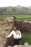
Wales 2003
|
SnowdonWednesday, 9/24 We climbed the friggin' mountain. That pretty much sums it up. OK, ok, some details . . . We got up that morning, saw there was a cloud parked on the top of Snowdon. But the weather forecast the night before assured us that things would be perfectly clear by late morning. I said "Hey, letĺs just take it easy, have a good solid breakfast, pack our bags, get everything ready, get a little bit of a late start." Alix concurred. I got a shower. We made breakfast. We packed everything up. There was still a cloud. "No biggie," I said. "We'll just wait a while. We've got plenty of time." Alix looked at me like I was nuts. "Itĺs 9:00 already. How late do you want to start?" "Well, all the guidebooks say that the Minerĺs track is only a 3-4 hour hike." "Yeah. To the summit. Then you have to hike back down." I saw she was serious. "Oh, shit."
I had completely screwed up, thought that the time given meant round trip.
Nope. Each way (the P.Y.G. was a similar length. We planned on going
up the Miner's track, taking the PYG down, since they both started at the same
place). Now, in my defense, the websites and other literature I had looked
at weren't all that explicit on this point. And, we had been walking 3-5k
in the mornings in prep for this, and knew we could get through a 5k walk in about
an hour. I did remember seeing that the round trip was about 11k, so there
was some sense in thinking that we could cover such a distance in 3-4 hours time,
allowing for breaks, sight-seeing, et cetera. Excepting of course that our
morning walks were on mostly level ground, with hills no more than maybe a hundred
feet. Snowdon was going to be a couple thousand feet of vertical ascent.
Duh. I felt like a total idiot. I was a total idiot. I
Anyway, it's a good thing my wife is a good sport, and tolerates my bouts of stupidity. We grabbed the gear and got going.
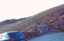
As it was, there was still plenty of parking in the lot at Pen y Pass, where
the PYG and Miner's tracks start. Good thing that it was the off season,
and during the middle of the week. We got out, loaded up, cinched down
the knee braces, swallowed a handful of ibuprofen, grabbed our hiking sticks,
and were underway. The Miner's track goes south then west, past Llyn
Teyrn. The path is mostly paved during this distance, and the climb is
steady but gradual enough that you donĺt break a sweat. The weather was
just stunning, bright and clear and a little crisp (fresher!). Some local
shepherds were out with their dogs, getting the flocks down off the mountainside,
Most of the exposed rock at this elevation is either slate or some variety of
tight-grained granite. However, there are veins of a brilliant, snow-white
quartz that are up to a foot thick, that trace through the sides of the mountain
and which look like frozen springs and waterfalls. Fascinating. We
crossed over the causeway at one end of the Llyn Llydaw reservoir, walked beside the
lake for a goodly distance, then sharply ascended another 500 feet to Glaslyn.
And there was wind. Good lord, there was wind. We sat ourselves down on the remains of a wall to enjoy a light snack: cheeses, bread, sausage. A seagull hovered not too far away, able to hang there in the face of the wind, waiting for us to toss scraps. When we did, the gull dived, snapping up the food, stalking the ground in front of us for a while before returning to a nearly stationary point in the air. A light mist passed through: remains of a cloud, skewered by Snowdon and then tossed down. But the sky kept clearing and clouding intermittently, and there were periods when the summit was visible for fairly long periods. We had hope.
Finishing our lunch, we then looked up the slope. This was the last third of
the distance we had to cover. The horizontal distance, that is. In
At this point we joined the PYG track, and continued on. For a while it
was just a fairly steady, though moderate, climb over decent trail. Then
we came to the base of the cliff. The path shifted off to the side,
shuffling up the cliff in a long switchback, all of it done in broad, wide
steps. In fairly short order, it was another 500 feet up, fighting not
just gravity but the wind all the way. It was a cold wind, blasting down
the side of the cliff, and at times it felt like it was going to send me
tumbling. Encouraging one another, we made it to the top of the cliff,
some 1300 feet higher than we had been at Glaslyn. This is where the PYG
Here the wind was just as strong, but bitter cold. The sweat of my exertion felt like ice water. I tightened the hood of the jacket over my hat to keep it from blowing away, could feel the wind slice through my clothing. Even the gloves I'd brought werenĺt sufficient protection from the wind. I don't like being cold, ever since I had a touch of hyperthermia many years ago, and usually am prepared to deal with it. This time I thought I was. But the temp at the summit station & cafe was just 5 degrees Celsius (call it 40 F.) with wind gusting at 30 mph. When I walked into the station, my glasses fogged over completely, and stayed that way for a good fifteen minutes. Partly this was due to how steamy it was inside the station, what with the furnace blasting, sweaty hikers, food cooking. Still, it was warm if crowded, and we got something hot to drink, a little something to snack on, while we relaxed and hoped for the cloud to lift. Because at the station, some 30 feet below the summit proper, we were right at the bottom edge of cloud. It was weird, being able to sometimes see out, beautiful vistas in all directions, other times looking straight into the thickest fog you could imagine, the windows nothing but blank grey canvases waiting to be painted. Finally, warmed if no dryer, somewhat recharged, the cloud lifted just a bit and we went out to see if Alix could get some photos from the summit itself. I don't know if she ever did, but there were glimpses I got as I waited just below the marker for her.
Well, the first part really was easy. The path was smooth, if steep, mostly just a long ramp back to the stile where the PYG and Miner's Tracks came together. Plus, we had the wind more or less at our back. Then we split off, and down the side of the cliff we had climbed up just an hour or so before, taking the giant's staircase one deep knee-crunching step at a time. Ugh. I took another handful of ibuprofen. Let me whine just a little: I don't have any cartilage in my left knee, the result of two surgeries some years back. So, stepping down creates a nice thud of bone on bone in the joint. And my right knee isn't much better. Walking on a flat surface doesn't present too many problems if I wear decent shoes. Even climbing up stairs, a ladder, or a hill doesnĺt result in too much pain. But a lot of going down stairs or dropping from one level to another anywhere from 1 to 3 feet lower presents me with a renewed interest in drugs. Anyway, enough whining. We descended. Then we descended some more. Then even more. In places I wondered how the hell we had come up, since I was bracing myself on some combination of: hiking stick, nearby boulders, Alix, the ledge I was dropping off of, et cetera. Perhaps the exhaustion I felt by this point in the climb up had made me numb to what I was doing. Not now, we were making progress heading down, but it was hard work. We reached the point where the PYG and Miner's Track diverged, the Miner's Track taking the scramble down which led to the stairway which led to Glaslyn. In fact, as we continued along the PYG, all of this unfolded below us and was easy to see. Happily, this section of the PYG was more or less a gentle descent, though the path was less developed (meaning it was just a wander across the mountainside in a direction we thought it should take). We made good time, enjoyed the sunshine (the wind had abated), the view, the little bits of Alpine landscape we were walking through. Did you know you can have a marsh/wetlands at the top of a mountain? We saw one. Well, OK, it was't on the top, but rather in the saddle between Crib Goch and Snowdon, but still. Pretty cool. Crib Goch is part of Snowdon, a ridge that runs off to the east, and along which is a path you can hike, if you like being on a 3' wide undeveloped path that is almost sheer cliff on either side, with a drop of several hundred feet. Charming. I didn't like the looks of it at all, and I was at the bottom looking up. We kept on, making good time. Which was necessary, since the sun was now low enough as to be behind the mountains. Oh, it wasn't going to get dark before we got down, but we didn't want to dawdle. At periodic intervals we'd reach another set of giant's stairs down, just three or four steps, but enough to make you dread the things. Then we turned a corner, came around the base of Crib Goch, and saw that we had to climb up a couple hundred feet, to make it through a pass. Unfair!
Regardless, we didn't have any choice in the matter. We climbed. Over
the pass. Figured that once we got to the other side, we'd only have about a
third of the distance to cover. This proved to be correct, as the maps told
us. But in looking closer, we realized that we had the absolute worst stretch
But at long last we saw Pen y Pass, and the parking lot with our car. By the time we got there, it was 6:30. It had taken us longer to descend the mountain than it had taken us to climb it. We stripped off the packs, the braces, tossed the hiking sticks in the boot. We drove down to Llanberis, then up to our cabin. As we unpacked the van, I stood there for a moment enjoying the setting sun as it sank into the Irish Sea. Going inside, we made a simple dinner, had a beer, and crashed early, footsore, exhausted and aching just about everywhere.
|
|
contact me: jim@afineline.org |
all work © James T. Downey, 1993-2006 photos © Martha K. John, 1994-2006 |
site designed and maintained by: Coeurbois Graphic Design |

 remind myself of moments like this whenever I get to feeling too smart.
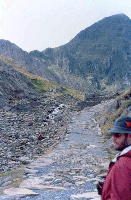 the yaps and baaing echoing through the hills and valleys. This first bit
of real climb comes as you go up from Llyn Teyrn to Llyn Llydaw, about a 30 degree
elevation that takes you up 300 feet fairly quickly. Here the path is paved,
but with giant, rough slabs of stone, more suitable to large trucks than foot
traffic. It was, after all, the way that slate and other goodies from the
interior of Snowdon were brought out (hence the name of the trail).
the yaps and baaing echoing through the hills and valleys. This first bit
of real climb comes as you go up from Llyn Teyrn to Llyn Llydaw, about a 30 degree
elevation that takes you up 300 feet fairly quickly. Here the path is paved,
but with giant, rough slabs of stone, more suitable to large trucks than foot
traffic. It was, after all, the way that slate and other goodies from the
interior of Snowdon were brought out (hence the name of the trail).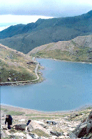 This is one of the purported lakes in the "Lady in the Lake" stories. And it's
perfect for the role: isolated, gorgeous, dramatic. It sits there,
perhaps 300 yards across at the widest point, at the foot of a sheer cliff of some
1600 feet up to the summit of Snowdon. When the sky was clear, there was a
brilliance to the water that almost made it glow, a slight tinge of blue-green
supposedly caused by a high copper content. When there was a cloud overhead,
snagged by Snowdon, the blue-green took on a flat, hard look not unlike the local
slate.
This is one of the purported lakes in the "Lady in the Lake" stories. And it's
perfect for the role: isolated, gorgeous, dramatic. It sits there,
perhaps 300 yards across at the widest point, at the foot of a sheer cliff of some
1600 feet up to the summit of Snowdon. When the sky was clear, there was a
brilliance to the water that almost made it glow, a slight tinge of blue-green
supposedly caused by a high copper content. When there was a cloud overhead,
snagged by Snowdon, the blue-green took on a flat, hard look not unlike the local
slate.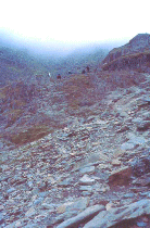 terms of elevation, it was more than we had climbed so far. In fact, from
that point on the climb was a 45 degree one, or worse. It started with a
good, easy to follow path of stairs carved in the rock, which then became what the
Brits call a 'scramble:' making your way through loose rock and boulders as
best you can, with no real discernable path. We climbed maybe 500 feet of
ascent this way. Yeesh. Now I was breathing hard, using my stick
regularly to help my footing, working. Alix, bless her heart, was keeping
up just fine, pausing occasionally to catch her breath, take some pix, enjoy the
scenery. There was plenty of scenery to enjoy. We had risen high
enough that out to the east the view opened up, revealing miles and miles of
gorgeous northern Wales.
terms of elevation, it was more than we had climbed so far. In fact, from
that point on the climb was a 45 degree one, or worse. It started with a
good, easy to follow path of stairs carved in the rock, which then became what the
Brits call a 'scramble:' making your way through loose rock and boulders as
best you can, with no real discernable path. We climbed maybe 500 feet of
ascent this way. Yeesh. Now I was breathing hard, using my stick
regularly to help my footing, working. Alix, bless her heart, was keeping
up just fine, pausing occasionally to catch her breath, take some pix, enjoy the
scenery. There was plenty of scenery to enjoy. We had risen high
enough that out to the east the view opened up, revealing miles and miles of
gorgeous northern Wales.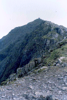 and Miner's Track trails join the Llanberis Path and the Snowdon Cog Railway.
It was only another 300 foot vertical ascent to the top, in a steady climb up the
well worn path.
and Miner's Track trails join the Llanberis Path and the Snowdon Cog Railway.
It was only another 300 foot vertical ascent to the top, in a steady climb up the
well worn path.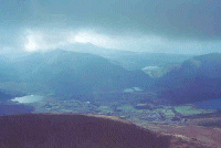 Eventually, we decided to leave, telling ourselves that while it would be easier
going downhill than climbing up, nonetheless we had a good 3-4 hour hike ahead of
us. And it was already about 2:00.
Eventually, we decided to leave, telling ourselves that while it would be easier
going downhill than climbing up, nonetheless we had a good 3-4 hour hike ahead of
us. And it was already about 2:00.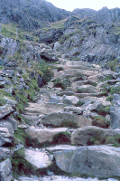 of trail ahead of us. It was 'scrambles' most of the way, but over boulders,
up and down, up and down, nothing but bone-bruising jolts and thigh-quivering climbs
in such rapid succession that frequent breaks were necessary. Alix looked at
me and said that it was a damned good thing we hadn't come this way to begin with,
because she would have tossed in the towel then and there. One particularly
nasty bit was sort of a spiral down with drops of four and five feet at a time.
I kept expecting to see safety ropes and climbing rigs. Yeesh. But the
end of this stretch I had worn off the tough rubber endcap of my hiking stick, since
I had been using it as a brace to lower myself so much on the rough rock.
of trail ahead of us. It was 'scrambles' most of the way, but over boulders,
up and down, up and down, nothing but bone-bruising jolts and thigh-quivering climbs
in such rapid succession that frequent breaks were necessary. Alix looked at
me and said that it was a damned good thing we hadn't come this way to begin with,
because she would have tossed in the towel then and there. One particularly
nasty bit was sort of a spiral down with drops of four and five feet at a time.
I kept expecting to see safety ropes and climbing rigs. Yeesh. But the
end of this stretch I had worn off the tough rubber endcap of my hiking stick, since
I had been using it as a brace to lower myself so much on the rough rock.
