

|
|
|
|
| writings || books || projects || madvertising || odds & ends || about || bio |
various essays on, well, art and culture lessons learned from this profession
ok, I'm not the guy from SNL,
mostly true stories from my more "it's all about me"
I’m at -7.13/-7.33 on The
Political Compass. Where observations on the human condition
Wales 2003
|
St. Cybi's (wait for it . . .) WellTuesday, 9/23 The rain of the night before was still around in the morning, but the weather forecast promised that would change before the morning was over. We looked up at Snowdon, couldn't see the summit. Couldn't even see the top third of the mountain. We decided that today wasn’t the day to try climbing it, since we'd be wet starting out, and there was no surety that the weather would turn to our favor. But what to do? I felt punk, needed some exercise. The little hike up to Dolwyddelan the day before wasn't enough. Another day of calm sightseeing from the seat of a car would make me miserable. Such is the danger of getting into a steady exercise routine. Alix suggested Pen Llyn, or the Lleyn Peninsula, the long arm of Wales that sticks out into the Irish Sea. We'd do a little hiking, stretch our legs, but not over-do it, in case the weather really was good enough on Wednesday to climb Snowdon. Sounded good. We loaded up the gear, packed some cheese and other goodies in the small soft-sided pack we’d brought for this purpose, jumped in the van, and took off. West to Caernarfon, then south on the A487 until we hit the A499, which branches off and runs along the north coast of Pen Llyn for a while. By the time we got there, the clouds had broken and the rain stopped.
Unlike Ynys Môn, which is only about a dozen miles to the north, Pen Llyn
isn't flat at all. In fact, it's pimpled with mountains. Not great
big mountains, granted, but real mountains, complete with cliffs and dramatic
terrain features. And there's a bunch of them. We wove our way
We were careful to make sure no birds got in, decided to go see if we could find the famed (take a guess) "Well of St. Beuno," which was supposed to be nearby. According to the maps, it was supposed to be just across the street and down a bit, but the signage on the road indicated otherwise. No luck. After pondering and wandering a bit in the cool morning air, we decided to move on.
One thing that Pen Llyn shares with Ynys Môn: there's a standing
stone, or a burial cairn, or the remains of some iron-age settlement/fort, or
some other noteworthy bit of history, in just about every grid square on the
Landranger map. And those grid squares are only a kilometer on a side.
We peeled off the A499 onto the B4417, through the town of Llanaelhaearn, past
St. Aelbaiarn's (yup) Well, up a steep climb and found a parking spot, just a
little pull-off on the side of the narrow country road. Because there,
dominating the skyline, was Yr Eifl - the three-peaked mountain. Putting
on our hiking boots, slapping on knee braces, grabbing our walking sticks and the
day bag, we set out. Up off the road via a set of steps, through a kissing
gate, and into a steep sheep pasture, walking along an ancient dry stone wall.
The sun was now bright, the sky brilliant, and there was a scream of fighter jets
as they zipped between the mountains of the peninsula. Yup, the RAF at play.
There's an airbase on the southwest end of Pen Llyn, and these guys seemed to be
doing laps, practicing their racing skills. It was somewhat disconcerting,
even a little concerning, since in the last two years I have come to regard the
Nonetheless, the climb was demanding enough to get the blood pumping, and before we crossed into the next section of pasture through another kissing gate I was feeling bouncy and full of energy. About halfway up the 1500 foot climb we stopped to take stock of our location and just appreciate the view. And there, just across the way from us, the next mountain over looked like a woman's breast, complete with a perfect nipple at the top. Hey, I wasn't the one who noticed this, my wife was. But once this was pointed out to me, I couldn't help but see it. We checked the map. Mynydd Carnguwch. Alix chuckled, checked her dictionary (yeah, she always had a pocket Welsh dictionary with her, a more substantial version back in the cottage). Seems that the Welsh, who have many different descriptive words for types of mountains the way the Inuit have different descriptive words for types of snow, have one that means "looks like a woman's breast." No, seriously. Gotta love a people who think that way.
Back to the van, and divest ourselves of the hiking gear. Time to go west. Stayed on the B4417, mostly following the line of the northern coast, until we found a pub advertising lunch. This far off the beaten tourist track, and it being off season, most places were closed until the evening. This place had a little beer garden in the back. We sipped, supped, watched seagulls. Alix drove after lunch, and the road took a turn to the south, heading out toward the point of the peninsula. We talked about going all the way out to the point, where we'd be able to view Ynys Enlli (Bardsey Island), reputed to be the 'Island of the Saints.' There must be a lot of wells there. But we took the highway (such as it was) down into Aberdaron, then across the south coast eastward through a maze of little unnumbered backroads around and about the countryside, finally emerging in the small seaside community of Abersoch. We found our way down to the beach, where we parked the van and enjoyed ice cream bars from a little shop as we walked along the dunes. Delightful. Picking up the A499 (it ends in Abersoch) we follow it along the coast to Pwllheli, stay with it as the highway turns north and across Pen Llyn towards Yr Eifl again. This because Alix wanted to visit a CADW site known as Ffynnon Gybi, which (all together now) translates to: "St. Cybi's Well." Even with Alix navigating, using the Landranger map, it's hard to get back close to this site. Eventually, we see a sign at a crossroads near Llangybi, pull the van off the road. The sign points one direction. But there was a little CADW sign over a kissing gate back the other way. The map says the Well is to the north of the road. We try and sort it out, walk back to the CADW sign then through the gate into a sheep pasture. There isn't much of a path visible. The directions in some little general tourist guidebook Alix has says that we're supposed to follow the path along a hedge, down the hill to where we'll see the Well. OK. There's a hedge, and the path does sorta look like it leads that way. Down we go. Through another kissing gate. But then the path just kind of stops. Where it stops there's another kissing gate into a cow pasture. But it doesn't look like the gate gets a lot of use. Wait, a little further down the hill, there's something . . . We drop down into a small hollow. There is some kind of spring there, burbling up through a simple rough stone basin, a couple of rusty metal bars across it to stop sheep from trying to drown themselves. That's it. Alix checks the guidebook. St. Cybi's Well was supposed to be famous, one of the most famous of the wells in all of Wales. I squat down next to the water, lightly touch my palm against the surface, try and get a sense of the place. Just springwater, cold and fresh, but nothing more. I don't pick up anything remotely energized or sanctified. Standing, wiping my hand on my jeans, I look at Alix and shrug. We look around again, back across that cow pasture. There isn't anything else anywhere around.
A little disappointed, we hike back to the car. There's still time to get
to Criccieth, one of my favorite castles in Wales, near the juncture where Pen
Llyn meets the mainland. We drive the few miles to the southeast, first
on the B4354 then on the A497, into and through the town. Criccieth is
perhaps the most dramatic of the Welsh-built castles, standing at the top of an
This is a lovely place. In fact, before you make the final climb to the plateau at the top, there are a number of park benches along the hillside, looking out over the beaches or out to sea. A perfect place to sit and enjoy the view, have lunch, perhaps cuddle. But, with limited time, we push on, up to the castle proper. What can I say? Criccieth is what one thinks of when one imagines a castle. It's not entirely intact, but there is plenty there for the mind to envision. The massive double D of the inner gatehouse is the most prominent feature, but there are substantial bits of the curtain wall complete with wall-walk, arrow loops, stairways and latrines. The principle towers are reduced but still impressive. The siting couldn't be better, making use of natural terrain features (cliffs) and a commanding view over the town and shore. One of the towers was even used as an engine tower, evidence of what was probably a trebuchet still visible. This would have given the defenders the ability to target ships all along the beach. It's brilliant. We clamored up into the inner courtyard, starting poking around the towers, climbing on the walls, looking out over the bay, when some small question prompted Alix to refer to the guide of the castle. Her jaw dropped. She pointed at the cover of the guide. There, under the bold headline "CRICCIETH CASTLE" was smaller print: "Pennarth Fawr Medieval Hall-House" and then at the bottom "St. Cybi’s Well." Quickly, she thumbs past the information about the castle, finds the part in the back about the well. Not only is there an extensive discussion of the history and layout of the well and its several buildings (complete with photos and diagrams), there's also clear-cut directions on how to find the well starting at Llangybi Church. "Whaddya think?" "We've got enough sunlight left. Let's give it another try."
And with that, we left Criccieth. The drive back to Llangybi didn't take
long. We quickly found the church in question, entered through the gate
into the courtyard. Following the directions in the CADW guidebook, we
crossed the churchyard, went to a stile at the northwest corner that took us
over the churchyard wall, dropping down into a field. From here there is
a clear path leading down into the valley, first running along the field's edge,
then through a kissing gate and descending through a bit of forest before emerging
across a field from the Well. Instantly, I knew we were at the right
St. Cybi was a 6th c. Welsh saint, though the oldest of the structures at the well can be dated only to about 1200. To me the place felt ancient, there was a depth and power there similar to what I sensed at Strata Florida, but moreso. I get goose pimples just remembering it. My awareness shifted, slowed, and a calmness and sense of peace came over me. I did a cursory examination of the cottage, but then walked behind the Well room to find the source of the stream which fed the pool there: it was a spring, unencumbered by metal bars, bubbling up in a stone-ledged pool complete with small steps, perhaps four feet across. I knelt on one knee, left hand on the cold stone slab, the right reaching down to caress the surface of the water. Just touching that water gave me an electric chill, and brought tears to my eyes. Those tears have returned as I write this. I paused there, and just felt the joy of that water through my fingers for a few minutes, before returning to the Well room. This is a substantial room, all the walls mostly intact but the roof missing. Perhaps 15 feet on a side, the pool in the center 8 or 9 feet across. Again, there were stone steps leading down into the pool. In the thick stone walls are several niches for sitting, perfect for contemplation. I sat. I just felt that place, felt the faith and devotion that had shaped it, and the deep source that fed it. The pool is quiet, the surface a mirror for looking up into the open sky. After what was probably only a few minutes, but what felt like hours, I again kneeled, reaching down to touch that smooth inviting surface. Here there was a different character to the energy, less raw, perhaps easier to digest. A sense of communion with all the souls who had entered that pool. A moment that stretched back centuries. I was speechless for a time. Alix knows me well enough, has seen me in these moments before, that she let me be, allowed me to just experience the place, until I was filled and ready to move again. With the silky texture of worn stone sliding under my fingers, I rose and left the pool, pausing only to pat the dark stone of the doorway and give thanks. We left the Well as twilight started to settle on the land. I remember walking back to the car, then driving back to Caernarfon, and on to the cottage. I remember making dinner, and spilling rice all over when I tried to open the plastic bag that held it, both of us laughing heartily. I can even tell you what else we had for dinner, and the brand of ale I drank. But all those memories are dim, perhaps eclipsed by the brilliance of that moment touching water. I'll no longer make fun of anyone's well.
|
|
contact me: jim@afineline.org |
all work © James T. Downey, 1993-2006 photos © Martha K. John, 1994-2006 |
site designed and maintained by: Coeurbois Graphic Design |

 along the edge of the sea, on the narrow strip of coast between a number of
these small mountains and the water, until we came to the small town of
Clynnog-fawr. This is the location of St. Beuno's Church, on the north
side of the highway just across from the little store that functions as the Post
Office (this is common throughout Britain). St. Beuno's is a medieval
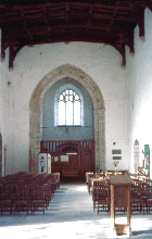
chapel in remarkable condition, complete with hammered beam ceiling, classic
layout mimicking the great churches of the monasteries with Nave, transepts, the
whole bit. Really excellent shape, though the sign on the inside of the
stout wooden door cautions the visitor to not allow in birds, due to the problems
they present.
along the edge of the sea, on the narrow strip of coast between a number of
these small mountains and the water, until we came to the small town of
Clynnog-fawr. This is the location of St. Beuno's Church, on the north
side of the highway just across from the little store that functions as the Post
Office (this is common throughout Britain). St. Beuno's is a medieval
chapel in remarkable condition, complete with hammered beam ceiling, classic
layout mimicking the great churches of the monasteries with Nave, transepts, the
whole bit. Really excellent shape, though the sign on the inside of the
stout wooden door cautions the visitor to not allow in birds, due to the problems
they present.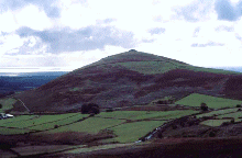 sound of jet fighters as being more than the local guard unit just getting in
enough stick-time to earn their flight pay.
sound of jet fighters as being more than the local guard unit just getting in
enough stick-time to earn their flight pay.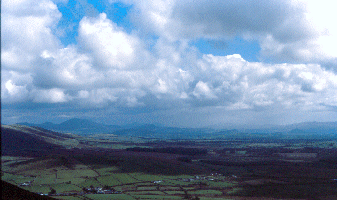 Anyway, we kept on climbing, up to about the 2/3 point. Here we paused
at another gate, resting on a pile of boulders. Jets flashed level with
us, to the south, the roar of their engines lagging far behind. From this
vantage we could see the sea to the south, even the castle looming over the town
of Cricceith in the distance. We had a bit of snack, some water, debated
whether to finish the climb to the summit, where there was supposed to be a burial
cairn. We decided that what we had done already was probably pushing it, if
we were going to climb Snowdon the next day. We just wanted to stretch our
legs a bit, after all. So, back down the hill; I was tempted to run headlong
down the slope in my slight giddiness, but my already achy knees pointed out just
how stupid an idea that was.
Anyway, we kept on climbing, up to about the 2/3 point. Here we paused
at another gate, resting on a pile of boulders. Jets flashed level with
us, to the south, the roar of their engines lagging far behind. From this
vantage we could see the sea to the south, even the castle looming over the town
of Cricceith in the distance. We had a bit of snack, some water, debated
whether to finish the climb to the summit, where there was supposed to be a burial
cairn. We decided that what we had done already was probably pushing it, if
we were going to climb Snowdon the next day. We just wanted to stretch our
legs a bit, after all. So, back down the hill; I was tempted to run headlong
down the slope in my slight giddiness, but my already achy knees pointed out just
how stupid an idea that was.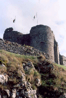 isolated hill right on the edge of the sea, completely dominating the town.
It was taken by Edward, and additional structure added, but it still retains the
classic "D" shaped towers so characteristic of the Welsh-built castles of the
13th c. We park on the street beside the CADW center, grab the camera and
the CADW guide to Criccieth (as I said, this is one of my favorite
castles, and we had been there previously and picked up the guide at that time),
and enter. The nice lady at the register asks us to please come down off
the castle before closing time at 6:00 (it was then about 5:00). We hike
up the path, enter the castle grounds.
isolated hill right on the edge of the sea, completely dominating the town.
It was taken by Edward, and additional structure added, but it still retains the
classic "D" shaped towers so characteristic of the Welsh-built castles of the
13th c. We park on the street beside the CADW center, grab the camera and
the CADW guide to Criccieth (as I said, this is one of my favorite
castles, and we had been there previously and picked up the guide at that time),
and enter. The nice lady at the register asks us to please come down off
the castle before closing time at 6:00 (it was then about 5:00). We hike
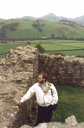
up the path, enter the castle grounds.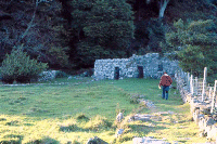 place. Crossing the bit of open ground, we came before a series of
ruins. To the right was a small stone cottage which was probably used by
the caretaker for the Well, perhaps as a dorm for those receiving the cure.
To the far left was a latrine building, a sort of stone outhouse. There in
the center, adjacent to the cottage, was the Well room.
place. Crossing the bit of open ground, we came before a series of
ruins. To the right was a small stone cottage which was probably used by
the caretaker for the Well, perhaps as a dorm for those receiving the cure.
To the far left was a latrine building, a sort of stone outhouse. There in
the center, adjacent to the cottage, was the Well room.
