

|
|
|
|
| writings || books || projects || madvertising || odds & ends || about || bio |
various essays on, well, art and culture lessons learned from this profession
ok, I'm not the guy from SNL,
mostly true stories from my more "it's all about me"
I’m at -7.13/-7.33 on The
Political Compass. Where observations on the human condition
Wales 2003
|
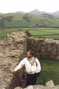
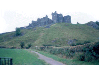
The Latches of her DreamsFriday, 9/19 I mentioned that Martin was doing a good job in Aura's absence. 'Tis true; next morning he made a lovely breakfast for us (yup, the full traditional. Is it any wonder I put on weight this trip?). But also let us watch his satellite tv there in the living room, catching up with what had happened in the US with Hurricane Isabel. Weird to hear about Washington being shut down like that when you're overseas, particularly on such a bright and pleasant day. This morning was one of our definite 'goals' for the trip: to visit Castell Carreg Cennan. We had viewed it from a distance on our last trip, thought that it was worth the time and trouble to hike up and explore this time. So, we packed the bags, made sure to have extra film, knee braces and water, jumped in the car and drove to the far side of Llandeilo, thence back into the boondocks to where Carreg Cennan waited. Parked the car, put on the knee braces, grabbed my hat and our shoulder bags, and off. Stopped in at the office there on the farmstead, where we found and purchased some walking sticks of local manufacture, knowing that they'd be handy not just for this castle, but for adventures in the north. Thus armed and ready, we made our assault on the cliff upon which the castle is perched.
OK, that's overstating it a bit. But not much. It's a vertical climb
of about 300 feet. The approach we took, up the gravel path, is the most
Wait, what do you mean you don't know what a kissing gate is? OK, there are two main pedestrian gates in use in the Welsh countryside. One is a latch gate, usually spring loaded or set up with weights, which you have to unlatch, then pass through, holding open all the while. When you let go of the gate it slams shut, the latch mechanism clipping shut (it's a nice, heavy-duty spring pin and plate system, which I've never seen in the States. Alix has been in love with these gate latches since our first trip to Britain in '94). The other variety is a free-swinging gate in a little enclosure that has just enough room for one person to enter, move the gate past, then exit. Both of these are very effective means of letting people through but keeping sheep and cows penned up. You will see cattle guards and the conventional wide gate, but those are usually where vehicles need to pass. Anyway, back to the castle. We entered the paddock, said hello to the cows standing there, avoided their scattered patties, and made our way up the final 40 or 50 foot rise to the entrance of the castle yard. Carreg Cennan sits at the top of this massive cliff. It has a commanding view of the whole area for miles. There's a natural cave up on the top. Is it any wonder that there's plenty of evidence of prehistoric use of the site? And of course an Iron Age hill fort was there. Lots of evidence that the Romans used the place. So the Lord Rhys made it the third major fortress of his Kingdom of Deheubarth in the 12th century. The castle didn't see a lot of action through history, was largely intact until the end of the Wars of the Roses, when (as with many of the castles in Wales) it was 'reduced' so as not to present a threat in the future. And while the structure was effectively rendered a ruin at this time, what remains of it today is damn impressive. You enter the outer courtyard on the east through the double pile which used to be the Outer Gate. This courtyard is where stables, et cetera were kept. In the center is what's left of a large lime-kiln, adjacent to which is a quarry. On the south edge of this courtyard is the 'cliff gallery' and a wall topping the cliff face. This allowed access into the natural cave from within the castle, and probably served as a storage area during much of the life of the castle. Stepping up to the walls here, looking down the face of the cliff, the Wind of Deheubarth makes itself known, whipping the hat off your head if you don't grab hold of it. The entrance into the castle proper from the outer yard is up a ramp barbican which includes two drawbridges. Then you come to the Middle Gate Tower, at which point you have to make a 90-degree turn, leaving your back exposed to said tower, in order to approach the massive Main Gate. This gatehouse was of classic double-tower construction, each half of which could be cut off and defended, and forced the entrant to pass through an enclosed corridor complete with portcullis at either end, murder holes, arrow slits, and so forth. The portcullises are gone, but most of the rest is there and easily understood.
You can rent a 'torch' (British for flashlight) at the ticket office. We, being seasoned castle-explorers, had ours in our bags. Down a number of steps into the 'cliff gallery,' which was mostly an enclosed loggia which looked out of the cliff face. This took you down a slope to where there was another series of steps into the cave itself. Lights on, we descended. Yup, it's a cave. Being from Missouri, which has hundreds of caves of various sizes and shapes ('The Cave State' used to be our state motto, until someone decided that bragging about holes in the ground really wasn't much of a tourist draw), I've seen plenty, and in fact we have a much larger and more elaborate cave on our property south of town. This was a fairly narrow type, but tall enough that I could walk without having to watch my head, the floor made more or less smooth by a couple of thousand years of use. We went about halfway back, according to the map of the place we had, decided that we'd seen enough, and made our way back out. Emerging into the daylight of the cliff gallery, we climbed the ramp up into the Inner Ward. After poking around a bit more on the inside, giving Alix a chance to change the roll of film in her camera, we went outside the castle and explored the outer courtyard and the surrounding grounds. The wind had picked up, and we enjoyed watching a hawk hover just above the edge of the cliff, riding the breeze. It’d be an excellent place to play with a hang glider or parafoil. But having neither, we decided to make our way back down the hill in a more conventional fashion. By now the weather had started turning a little grey, a dampness in the air threatened rain. We drove back to Llandeilo, thence to a small place called Talley Abbey which Alix had noted while studying the map earlier. (Oh, a note . . . by this time we had shifted over from a general map of Wales to the use of Ordnance Survey Landranger maps. These are about like your standard USGS topo map of 1:50,000, or about 1.25 inch to the mile. VERY handy for finding little out-of-the-way places, such as just about anything in Wales.) Talley Abbey had been established by the White Cannons of the Premonstratensian Order. Try saying that three times fast. From what I can gather, the Premonstatensians were like the Cistercians, only moreso.
There isn't much there at Talley Abbey. Just a gate with the CADW sign,
and a note that for more information to call at the house across the street.
But there are some interesting ruins, so we wandered in. The footprint of
the church, as seen by the foundations still remaining, is misleading: only
about half of that structure was ever built. Getting past that, you get to
short walls and piers which are all that remain of the church, except two walls
of the central tower, rising to some 85 feet. What was weird as we were
looking at the one taller wall was that it looked like there was a passageway
Nice enough, and a beautiful view of the surrounding hills. But we decided to go in quest of lunch. Back to Llandeilo, while looking for someplace to get a meal, saw a little Home Depot-oid store, and on a whim I popped in. Alix looked at me like I was nuts. "Latches," I said. We went inside and inquired. They didn't have 'em, but suggested that another store on the other side of town, a place called "The Farmers of Camarthen" would. We left heading that way, decided to stop downtown and try out a little Fish & Chips take-away place we had seen. Alix had a pastie, which she thought was OK. I got fish & chips, which turned out to be about the worst I've ever had. So if you find yourself on the main drag of Llandeilo looking for food, maybe with a hankerin' for fish & chips . . . stop in a pub. Anyway, after eating what I could of the fish & chips (grease saturated, soggy, breading on the fish just a little too orange to give one confidence), we went inside the "Farmers of Camarthen." Like a Farmer's Coop back home, I thought, the moment we walked in. In a trice Alix had located the latches of her dreams. We got two, 7 pounds sterling each (they weigh more than that, believe me), or about $11.50 each. Not sure what they'll get used on, probably something down at the farm. Lunch and shopping complete, we went over to the extensive park on the west side of town which includes the castle and grounds of the third great fortress of the Lord Rhys: Dinefwr. For the non-Welsh speakers in the crowd, that's pronounced 'din - EH - voor.' We got there, parked the van, popped into the office and flashed our CADW cards to the nice man there. Odd thing: the office, a modern structure, has a wooden deck which had chicken-wire mesh on the top of the deck boards. Alix and I speculated that it would be to prevent slippage, if you had mud or muck (the park has an ample supply of sheep and cattle) on your shoes. Interesting . . . Castle Dinefwr is Alix's ancestral home; well, as well as anyone can figure anyway. When we had been here previously the castle was undergoing some renovation work, which had been completed in the interim. We were anxious to see it. We got out the walking sticks, reapplied the knee braces, slung camera and hiking bags, and set out. From the office, it's a goodly hike up to the castle. Not so much in terms of climbing, though there is some of that. But in terms of distance. About 3k, each way. Easy enough, though we were both a little wearied by the climb up to see Carreg Cennan earlier. But we made the castle in good time, the weather cloudy and cool but remaining dry. Crossed over what had been a drawbridge from the site of the Old Town (nothing remains there now but brambles) into the lower portion of the Outer Ward. Past the upper portion of the Outer Ward, along a recently repaired stone wall facing the cliff on the left. Through the location of the Middle Gate, under the watchful eye of the great Tower Keep, up the ramp of the barbican, caught between high walls on either side, through the Inner Gate and into the Inner Ward.
Yup, they had finished the renovations. Now you could walk along the curtain
wall on two sides of the castle, looking down the side of the cliffs there.
Yes, like Dryslwyn and Carreg Cennan, this castle had been superbly situated for
defensive purposes. And like Dryslwyn, which we could just make out to the
west, it commanded the valley of the River Tywi, and so served a strategic purpose
And you could again feel the Wind of Deheubarth when you climbed up on the walls or ascended any of the towers (you can get up into all three of the towers there, at least to some extent). But you feel it most on the Tower Keep, the stronghold of the castle, several stories above the walls, with a view that encompasses much of the ancient kingdom. Since we had been there before, we knew the layout of the castle, quickly scrambled to the best places, lingering then to enjoy the whistle of the wind, the warmth of sun breaking through low clouds now and again. After a while, it getting by this point well into afternoon, we decided to hike back to the car, taking a different route back than the one we took up, enjoying the park and the 300+ year old trees which grace it. By the time we got back to the car, there was a chill to the wind, a dampness that again threatened to turn to rain. It was late afternoon, and we thought to go back to the B&B, then to sort out dinner plans. But on the way back, Alix suggested that we might want to see if we could find something which Martin, our host at our B&B, had told us about: the massive Iron Age hill fort on top of Y Garn Goch, a mountain which stood across the Tywi valley from Blaen-y-Garn (our B&B). When I say massive, I mean just that: some 23 acres in size, walls (now just big damn piles of rubble) which would have been measured in meters of thickness. Martin had told us that it's a good hike of a day to scale the thing from the valley floor. Using our Landranger Map we thought perhaps we could get somewhat closer to the top, and thereby make the ascent more manageable.
After a few misturnings, we succeeded in just that, found a small carpark with a
trail leading up to the site of the hill fort. Again donning braces,
grabbing bags, and securing hats, we set off. By now my knees were starting
to object to all that I had put them through that day. But it was well worth
it. We followed the path, which wound through fern and bracken, leading up
and up. We crested the top of one hill, only to realize that there was a
taller and much larger hill further on. With a wary eye on the mist and rain
we could see descending further down the valley (Dinefwr should have been visible
We stopped for gas on the way back, then went into town to get some Indian take-away from a place across the street from the fish & chips greasy spoon. But we'd had this place recommended to us, and it proved to be a good choice. It started seriously raining before we got home, but we curled up in our room and enjoyed a delightful meal before crashing, foot-(knee) sore and tired from our multiple adventures of the day.
|
|
contact me: jim@afineline.org |
all work © James T. Downey, 1993-2006 photos © Martha K. John, 1994-2006 |
site designed and maintained by: Coeurbois Graphic Design |

 gentle route (the others being well-neigh impossible without some appetite for
freestyle climbing), but is a climb nonetheless. By the time we went
through the kissing gate and into the paddock which is the last more or less
level area before making the final climb to the castle . . .
gentle route (the others being well-neigh impossible without some appetite for
freestyle climbing), but is a climb nonetheless. By the time we went
through the kissing gate and into the paddock which is the last more or less
level area before making the final climb to the castle . . .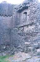 Only after passing through the Main Gate did you enter the Inner Ward. And
of course, surrounding this are several towers (one of which, curiously, is round
in construction) which both anchor the curtain walls and are able to survive
independent of one another, at least in theory. There's evidence of the
original wall walk, and the views out are all stunning. But after exploring
the remains of the towers, the great hall, and even the baking oven, we decide
to venture down into the cave.
Only after passing through the Main Gate did you enter the Inner Ward. And
of course, surrounding this are several towers (one of which, curiously, is round
in construction) which both anchor the curtain walls and are able to survive
independent of one another, at least in theory. There's evidence of the
original wall walk, and the views out are all stunning. But after exploring
the remains of the towers, the great hall, and even the baking oven, we decide
to venture down into the cave.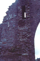 inside it. A passageway which couldn't be two feet wide. We couldn't
make sense of this until we were looking at some guide books later, which indicated
that these passageways lead to rooms high in the tower. The rest of the
layout of the church was pretty easy to figure, as it followed the standard plan
of medieval churches in Britain. Nave to the west, north and south transepts,
Presbytery to the east. The Sacristy was where it should be, the cloister
evident by foundation only to the south of the church.
inside it. A passageway which couldn't be two feet wide. We couldn't
make sense of this until we were looking at some guide books later, which indicated
that these passageways lead to rooms high in the tower. The rest of the
layout of the church was pretty easy to figure, as it followed the standard plan
of medieval churches in Britain. Nave to the west, north and south transepts,
Presbytery to the east. The Sacristy was where it should be, the cloister
evident by foundation only to the south of the church.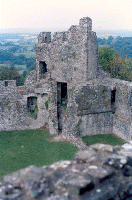 as well. Dinefwr is a large castle, certainly by the standards of the native
Welsh castles, and even approaches the size of some of the Edwardian castles found
in the region. For good reason, as it had been the seat of Deheubarth.
as well. Dinefwr is a large castle, certainly by the standards of the native
Welsh castles, and even approaches the size of some of the Edwardian castles found
in the region. For good reason, as it had been the seat of Deheubarth.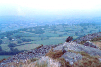 from this vantage point, but was shrouded from us), we picked up the pace a bit
and forced on. Down through the saddle between the two mountain tops, then
up again, and now we scrambled over the remains of the walls, out onto a large
plain. It was magnificent. The wind picked up, and a light drizzle
started to fall. I felt touched by something ancient, could almost hear
voices around me from 2,000 years ago. As it started to grow dark, we made
our way down the path, back to the van, getting there before we were really wet.
from this vantage point, but was shrouded from us), we picked up the pace a bit
and forced on. Down through the saddle between the two mountain tops, then
up again, and now we scrambled over the remains of the walls, out onto a large
plain. It was magnificent. The wind picked up, and a light drizzle
started to fall. I felt touched by something ancient, could almost hear
voices around me from 2,000 years ago. As it started to grow dark, we made
our way down the path, back to the van, getting there before we were really wet.
